


Voting District P05, Jones County, North Carolina
About
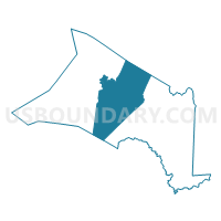
Outline

Summary
| Unique Area Identifier | 640583 |
| Name | Voting District P05 |
| County | Jones County |
| State | North Carolina |
| Area (square miles) | 91.09 |
| Land Area (square miles) | 90.77 |
| Water Area (square miles) | 0.32 |
| % of Land Area | 99.65 |
| % of Water Area | 0.35 |
| Latitude of the Internal Point | 35.05050890 |
| Longtitude of the Internal Point | -77.36787460 |
Maps


Graphs
Select a template below for downloading or customizing gragh for Voting District P05, Jones County, North Carolina


Neighbors
Neighoring Voting District (by Name) Neighboring Voting District on the Map
- Voting District 07, Craven County, NC
- Voting District 08, Craven County, NC
- Voting District GB12, Onslow County, NC
- Voting District P01, Jones County, NC
- Voting District P02, Jones County, NC
- Voting District P03, Jones County, NC
- Voting District P04, Jones County, NC
- Voting District P07, Jones County, NC
Top 10 Neighboring County Subdivision (by Population) Neighboring County Subdivision on the Map
- Township 3, Craven County, NC (3,462)
- Township 9, Craven County, NC (3,396)
- Township 2, Pollocksville, Jones County, NC (2,612)
- Township 1, White Oak, Jones County, NC (2,038)
- Township 3, Trenton, Jones County, NC (1,981)
- Township 7, Beaver Creek, Jones County, NC (1,074)
- Township 4, Cypress Creek, Jones County, NC (907)
- Township 6, Chinquapin, Jones County, NC (641)
- Hofmann Forest UT, Onslow County, NC (5)
Top 10 Neighboring Place (by Population) Neighboring Place on the Map
Top 10 Neighboring Unified School District (by Population) Neighboring Unified School District on the Map
- Onslow County Schools, NC (148,667)
- Craven County Schools, NC (103,505)
- Jones County Schools, NC (10,153)
Top 10 Neighboring State Legislative District Lower Chamber (by Population) Neighboring State Legislative District Lower Chamber on the Map
- State House District 14, NC (84,004)
- State House District 13, NC (76,622)
- State House District 12, NC (63,600)
Top 10 Neighboring State Legislative District Upper Chamber (by Population) Neighboring State Legislative District Upper Chamber on the Map
Top 10 Neighboring 111th Congressional District (by Population) Neighboring 111th Congressional District on the Map
Top 10 Neighboring Census Tract (by Population) Neighboring Census Tract on the Map
- Census Tract 9603, Craven County, NC (6,858)
- Census Tract 1.03, Onslow County, NC (5,415)
- Census Tract 9203, Jones County, NC (3,489)
- Census Tract 9202, Jones County, NC (2,776)